

P3: Magnetostratigraphy and geology of Cenozoic sections related to the Columbia River-Yellowstone plume system

Project leader
Dieke Gerritsen
Supervisors
Prof. Stuart Gilder, Prof. Anke Friedrich
Advisors (int.)
Dr. Michael Wack (LMU), Dr. Simon Kübler (LMU), Dr. Donja Aßbichler (LMU)
Advisors (ext.)
Prof. Robert Anderson (Univ. Colorado), Prof. Brian Wernicke (CalTech)
Description
Models of dynamic topography need to be tested against and calibrated by the geological record. Specifically, this RTG is built on a geological model that ties the event-based records of uplift, deformation, and erosion to the sedimentary record and landscape evolution. The volume and rates of erosion, the sedimentary record will be constrained by quantifying sedimentation rates, volume and provenance by synthesizing existing data and by targeting strategic sections for new magnetostratigraphic and geo-/thermochronological work. Magnetostratigraphy gives a detailed time model of the sedimentary record preserved in the distal region of a dynamically active region, thereby yielding a very precise 2D-deposition rate. The sedimentation time-model enables observation of changes in source characteristics based on the types and abundances of magnetic minerals. Magnetic anisotropy provides the possibility to place constraints on paleo-flow directions and hydrodynamic transport conditions. Finally, the volume of material eroded from the source region will be reconstructed by a combination of provenance analysis, budget calculations, and landscape modeling using the Landlab tool kit, which is the main focus of P7.
Background/motivation for the project
Mountains are typically formed via horizontal plate motion. Another way to build mountains is related to the buoyant uplift of hot mantle material that pushes the crust upwards. This latter process is called dynamic topography. Although computer models show dynamic topography can generate mountains up to 2000 m more than a reference baseline, this needs testing and calibration from the geological record. We are focusing on the Yellowstone hotspot (USA) as a test case.
As mountains build, they become eroded. The sediments shed from the mountains and deposited in nearby basins reflect the erosion efficiency, so by precisely dating the sediments, we can calculate the deposition rates. We do this via magnetostratigraphy, which gives a detailed time model of the sedimentary record by matching magnetic polarity flips with a global reference. Moreover, studying the rock magnetic properties through time gives additional information about the source of the rocks. The combined datasets yield insights on the development of dynamic topography.
Main objectives
- Compilation and synthesis of existing sedimentary-budget and -rate data for the target region (phase I: western North America) to construct an empirical model of evolution of large river systems.
- Identification of regions of critical data importance and implementation of a sampling strategy to acquire magnetostratigraphic, thermochronological, and provenance-suitable rock sections.
- Determination of detailed 2D-sedimentation rate using magnetostratigraphy.
- Map the target region stratigraphically to visualize the distribution of unconformities and hence hiatus, which will be tied to the dynamic uplift events in the source region.
- Determination of the timing of erosion and location of the source region based on provenance and chronological analyses.
- Determination of magnetic anisotropies in the sedimentary records in order to determine the direction and velocity of paleo-stream flow.
- Preparation for future analog experimental flume studies to better quantify the relationship between hydrodynamic regime and magnetic anisotropies. Magnetic anisotropy can also indicate strain conditions acting since sedimentation.
RTG coupling
Input:
- Geological model (P4) provides expertise on sampling site selection.
Output:
- Paleoflow directions and changes of sedimentation rates over time of study sites as input for plume-stratigraphic model (P4), the landscape evolution model (P7) and the lithospheric transfer function (P8). In particular, uncertainties will be incorporated into the integrated process model (P9).
- The combined output of P3+P7 is a sequential mapping of river network evolution on the interregional scale of interest. This model will then be incorporated in the event-and process-based geological model (P4).
- The sequential paleodrainage maps serve as a rough proxy for paleotopography needed in P1, P2, and P7 via further integration and analysis by P4.
Preliminary results:
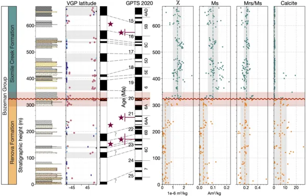
We initially focused on a regional unconformity present in the northern Rocky Mountains, which lies in the margin area of the Yellowstone plume. The timing of this unconformity matches with the expected development of dynamic topography in the plume stratigraphic model. We collected 9 stratigraphic sections during two field seasons, netting a total of ~1100 samples, and performed detailed paleo- and rock magnetic analyses. We constructed a radiometrically calibrated magnetostratigraphy for one of the sections and placed the end of the unconformity at ~20.1 Ma with a duration up to 1.5 Myr. Rock magnetic experiments show that the unconformity is marked by an abrupt increase in magnetite concentration in all sections. This reflects a reorganization in sediment source of the region, which persisted for at least 7.5 Myr. Active uplift as well as drainage network reorganization seemingly contributed to the formation of the unconformity, related to a change in tectonic regime such as the arrival of the Yellowstone plume and/or the onset of Basin and Range extension.

This year, we worked in western Washington, the distal region of the Yellowstone plume, to compare the results from the northern Rocky Mountains. We collected more than 600 samples, most along one continuous stratigraphic profile. Stay tuned for more exciting results in the future!
Presentations:
- Poster – Castle Meeting 2022: Influence of Data Filters on the Position and Precision of Paleomagnetic Poles: What Is the Optimal Sampling Strategy?
- Poster – GSA 2022: Thesis research plan: Magnetostratigraphy and rock magnetism in the western US
- Poster – AGU 2023: Magnetic Tracing of Lost Time in Cenozoic Sediments from SW Montana
- Talk – Castle Meeting 2024: Magnetic Tracing of Lost Time in Cenozoic Sediments from the northern Rocky Mountains, USA
- Talk – GSA 2024: Magnetic Tracing of Lost Time in Cenozoic Sediments from the northern Rocky Mountains, USA
Publications:
- Gerritsen et al. (submitted): Magnetostratigraphy and source characterization across the early Miocene unconformity, northern Rocky Mountains, USA