Processing models for analysing the 3D vibration response of structures using terrestrial laser scanners (PROVILAS)
This project aims at establishing a methodological procedure for the areal capturing of the vibration response of acquired structures. For this, a suitable approach is to be developed which combines the 3D-measurement data with a processing model. This processing model compensates the too low repetition rate of a 3D scene when using a terrestrial laser scanner and pushes the limits of the temporal resolution of the recorded geometric changes.
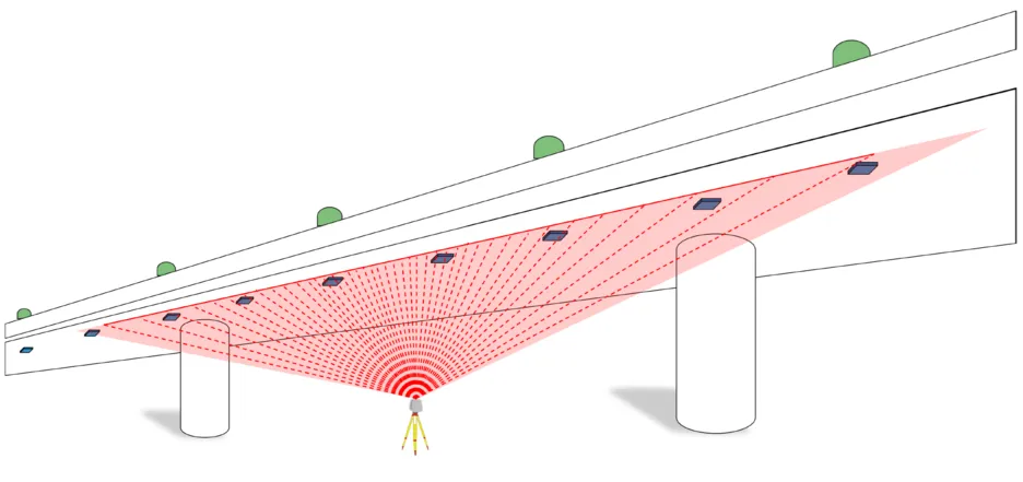
3D-terrestrial laser scanners are usually employed for the areal capturing of the geometry of various structural measuring objects. Repeated measurements enable the detection and analysis of changes in the structures’ geometry with a very high spatial resolution. Most scientific efforts to establish 3D-terrestrial laser scanning for areal deformation monitoring focus on an epoch-wise treatment of the scans, where the temporal resolution between the epochs is rather low at the order of several hours, days or longer. In this context, the quantification and modelling of the scanner’s measurement uncertainty plays an important role for the statistical assessment of the deformations. Excepting the spatial downscaling to profile laser scanning, 3D-terrestrial laser scanning was not used up to now when the temporal changes of the measuring objects occur due to vibrations. Their repetition rate is too low with respect to the temporal scale of these changes.
This project aims at establishing a methodological procedure for the areal capturing of the vibration response of acquired structures. For this, a suitable approach is to be developed which combines the 3D-measurement data with a processing model. This processing model compensates the too low repetition rate of a 3D scene when using a terrestrial laser scanner and pushes the limits of the temporal resolution of the recorded geometric changes.
Different processing models relating single measured points by temporally and spatially constraints to each other are deployed. The redundancy of the measurements generated in this way is used for estimating the parameters describing the vibration response of the structure. The deployed processing models combine different vibration models – parameterizing the vibration’s spatial and temporal behavior - with different parameter estimation models, e.g. regression, Kalman filtering and artificial neural networks. Furthermore, they also include measurement models describing the laser scanner’s measurement uncertainty focused on short-term effects. The performance of the different processing models is assessed by means of synthetic data (simulations), by means of lab-tests performed on representative specimens and by means of real data sets, measured at a bridge and a noise barrier wall.
This project establishes for the first time an effective 3D-laser scanning based methodology for a spatially comprehensive capturing and modelling of a structure’s vibration response, without requiring direct access to the object. This approach to detect and model the vibration behaviour opens up a new field of operation for 3D-terrestrial laser scanning.
As principal investigators, Prof. Christoph Holst (Technical University of Munich, Chair of Engineering Geodesy) and Prof. Hans Neuner (TU Wien, Research Division Engineering Geodesy) cooperate closely in this project.
The duration is from 2024 until 2027.
The Research Unit is funded by the DFG (German Research Foundation).