
Extract4D
Generalized Extraction of Surface Dynamics from Multimodal 4D Point Clouds for Topographic Monitoring of Earth Surface Processes and their Interactions
Project Description:
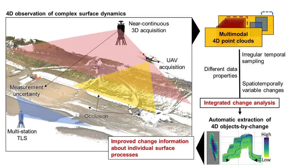
Topographic observation of landscape dynamics provides valuable insights into Earth-shaping processes and environmental drivers. As surface dynamics occur on various spatiotemporal scales, better monitoring and characterization of these activities will improve our understanding of environmental processes and human-environment interactions. This information can enhance environmental models of natural processes and human impacts.
Near-continuous 3D observation of local landscapes (i.e. the acquisition of 4D point clouds) significantly enhances the monitoring of surface dynamics. Current time series-based change analysis can effectively extract information about surface activities across various spatiotemporal scales but challenges remain in the transferability and generalization between different data sources (laser scanning and photogrammetry) and different use cases. There is an urgent need to adapt and extend time series-based methods of change analysis in 4D point clouds with adaptive, irregular temporal sampling (from sub-daily to annual) and multimodal sources (e.g., terrestrial and UAV platforms).
This project aims to develop data-driven methods for change analysis using multimodal 4D point clouds with adaptive temporal sampling, enabling automatic extraction of surface activities across different data sources and geographical environments. Such advances will enhance topographic monitoring and support a wide range of environmental research applications.
The developed methods will be applied to several case studies within the project, including coastal dynamics in the Netherlands (in collaboration with Geoscience & Remote Sensing und Coastal Engineering at TU Delft), soil surface processes in agriculture (in collaboration with TU Dresden), and salt marsh dynamics (in collaboration with Geosciences Rennes).
Objectives:
- Generalization of time series-based change analysis for multisource 4D point clouds
- Integration of multimodal 3D time series
- Transferability between use cases across different geographical environments
Publications
- Anders, K.; Kempf, D.; Albert, W.; Andriushchenko, P.; Huang, X.; Hulskemper, D.; Isensee, T.; Kapitan, D.; Tabernig, R.; Weiser, H.; Winiwarter, L.; Zahs, V.; Höfle, B.: py4dgeo: Open-source scientific software for topographic change analysis in 3D/4D geographic point clouds. SoftwareX 34, 2026, 102670 more… BibTeX Full text ( DOI )
- Huang, Xiaoyu; Letard, Mathilde; Lague, Dimitri; Höfle, Bernhard; Tabernig, Ronald; Leroy, Paul; Anders, Katharina: Time-Adaptive Change Analysis through Extension of the M3C2 Algorithm using Multi-Modal Laser Scanning Data in a Salt Marsh Environment. ISPRS Annals of the Photogrammetry, Remote Sensing and Spatial Information Sciences XI-2-2026, 2026, 623-630 more… BibTeX Full text ( DOI )
- Hulskemper, D.; Antolínez, J. A. Á.; Lindenbergh, R.; Anders, K.: Coastal process understanding through automated identification of recurring surface dynamics in permanent laser scanning data of a sandy beach. Earth Surface Dynamics 14 (3), 2026, 329--359 more… BibTeX Full text ( DOI )
- Letard, Mathilde; Naylor, Peter; Anders, Katharina: Spatiotemporal reconstruction of 4D point clouds at different time scales through implicit neural representations for topographic monitoring applications. ISPRS Annals of the Photogrammetry, Remote Sensing and Spatial Information Sciences XI-2-2026, 2026, 527-534 more… BibTeX Full text ( DOI )
- Lindenbergh, Roderik; Anders, Katharina; Campos, Mariana; Czerwonka-Schröder, Daniel; Höfle, Bernhard; Kuschnerus, Mieke; Puttonen, Eetu; Prinz, Rainer; Rutzinger, Martin; Voordendag, Annelies; Vos, Sander: Permanent terrestrial laser scanning for near-continuous environmental observations: Systems, methods, challenges and applications. ISPRS Open Journal of Photogrammetry and Remote Sensing 17, 2025, 100094 more… BibTeX Full text ( DOI )
- Tabernig, Ronald; Albert, William; Weiser, Hannah; Fritzmann, Patrick; Anders, Katharina; Rutzinger, Martin; Höfle, Bernhard: Temporal aggregation of point clouds improves permanent laser scanning of landslides in forested areas. Science of Remote Sensing 12, 2025, 100254 more… BibTeX Full text ( DOI )
- Ulm, Maximilian; Elias, Melanie; Eltner, Anette; Lotsari, Eliisa; Anders, Katharina: Automated change detection in photogrammetric 4D point clouds – transferability and extension of 4D objects-by-change for monitoring riverbank dynamics using low-cost cameras. Applied Geomatics, 2025 more… BibTeX Full text ( DOI )
- Wang, Jiapan; Anders, Katharina: Unsupervised Deep Clustering on Spatiotemporal Objects Extracted from 4D Point Clouds for Automatic Identification of Topographic Processes in Natural Environments. ISPRS Annals of the Photogrammetry, Remote Sensing and Spatial Information Sciences X-G-2025, 2025, 929-936 more… BibTeX Full text ( DOI )