Project Description
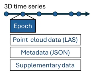
4D topographic observations, i.e., dense 3D time series, are acquired using laser scanning or photogrammetry to assess change in a scene over time. Unlike traditional datasets collected at intervals like seasons or years, these time series often have hundreds or even thousands of data points (called "epochs"). Processing this type of data is challenging because there are no consistent standards for handling time-dependent metadata, such as timestamps or essential processing details (e.g., transformation matrices). Instead, this information is often provided in user-specific formats, making it hard to reuse the data in different projects or tools. As more researchers work to share these valuable 4D datasets, it is clear that standardized, easy-to-use practices for managing metadata are needed to make the data more accessible and reusable.
This pilot project focuses on creating a standardized approach for handling 3D time series data, which are increasingly used in Earth system sciences. The goal is to develop a framework that automatically generates standardized time-dependent metadata for 3D time series data independent of the data sources or temporal sampling. This will include tools, guidelines, and a main use case to streamline workflows for researchers in fields like geomorphology, hydrology, and ecology.
Objectives
- Harmonize and automate time-dependent metadata generation for 4D datasets.
- Propagate the good practice in streamlined 4D data handling.
- Provide comprehensive materials and tools for the Earth science community.
For further details, please check NFDI4Earth Pilots.