

P7: Transient landscape evolution through response models to plate and plume mode

Project leader
Max Rau
Supervisors
Prof. Michael Krautblatter, Prof. Anke Friedrich
Advisors (int.)
Dr. Simon Kübler (LMU)
Advisors (ext.)
Dr. Kerry Leith (ETHZ), Prof. Greg Tucker (Univ. Colorado)
Description
Landscapes respond to dynamic topography changes by mass redistribution. While existing landscape evolution models often apply diffusion models for the calculation of slope evolution, we will also apply physically constrained slope evolution models in this project. Initially our landscape evolution models will take information on space-time patterns of surface uplift and subsidence from P6 and P8 and from P1, P3 and P4 and will be designed to operate on interregional scales to model the long-term landscape evolution. With input from P6, the landscape evolution models will be applied to individual plume-mode systems with further corrections for isostatic response (P4, P8). We will also model exemplary valley transects with slopes in (dis-)continuum by mechanically constrained slope-evolution models, to include the effects of horizontal stresses produced by the plate and plume modes. The controls of stress environments on valley evolution can be implemented via thresholds (1) on microcrack initiation as a percentage of uniaxial compressive strength, (2) on principal stress ratio (σ1 / σ3) or (3) on differential stress (σ1–σ3) (Leith et al 2014). This project will design a physically derived landscape evolution model applicable to both, compressive (convergent plates) and extensive (plume mode) settings controlled by the uplift from the geodynamic model and the crustal stresses from the lithosphere model and will produce differential erosion rates spanning over at least 3 magnitudes that feedback as isostatic response to the geodynamic and lithosphere model.
Motivation
The evolution of landscapes and drainage systems is the integrated result of multifaceted processes ranging from surface erosion and sedimentation to lithospheric tectonics and mantle convection. Due to the further development of numerical landscape evolution models (e.g., TTLEM, landlab, OpenLEM) in recent years, these models are increasingly suitable for checking and testing existing or new hypotheses on landscape development. This is of great importance for our Uplift project, as the Earth's surface preserves these long-wave signals of mantle convection in the image of the landscape on large temporal and spatial scales. By better understanding the parameters that contribute to the formation of large-scale landscapes, we can also better understand theories of past mantle convection (e.g., areas of dynamic topography).
Main objectives
- Develop forward models of stream-power driven incision to visualize the paleotopographic evolution of target regions and adapt the model design for the anticipated interregional scales of concern to the RTG.
- Calibrate the forward models by sensitivity analysis of relevant parameter sets such as steepness index, hillslope diffusivity, erosion rates, sediment settling velocity.
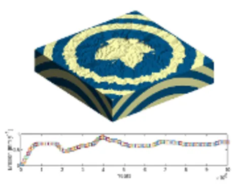
- Co-develop (jointly with P3/P4) a calibrated inverse modeling strategy to link with input/output from other RTGs by incorporating physical parameters constrained empirically from magnetostratigraphic, sedimentary, thermochronological information bearing on the age and evolution of the landscape. Modeling of radial stream networks and concentric escarpments and their evolution, generated during plume uplift and dispersal.
- Deriving parameterizations of uplift rates and horizontal crustal stresses produced by the geodynamic and lithosphere model in this proposal by adapting local-scale models to regional scales.
- Modelling differential erosion rates spanning over at least 3 magnitudes that feedback as isostatic response to the geodynamic and lithosphere model
RTG coupling
Input:
- Trajectory of Earth’s dynamic topography induced by mantle flow from past to present from P6.
- Contemporary uplift rates from P1, sedimentation rates from P3, and geological uplift rates from P4 serving to verify the landscape models
Output:
- Quantification of interregional surface mass redistributions from landscape evolution for P4 and P8.
- A refined and physically consistent model of paleotopography as a function of time serving as tests for assumed model parameters in P6.
- Results of river profile analysis (P3).
- Sensitivity of model parameters (P9).
- State of the art visualization of model output and observational data sets (in connection with P10)
Preliminary results
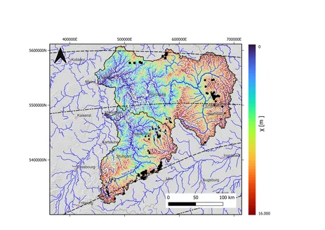
The geologically and tectonically complex Central Europe served as our first area of investigation. The tectonic history of Central Europe can be divided into four phases since the Late Cretaceous: 1) thrusting of basement blocks (90-70 Ma), 2) domal uplift of a wide area (75-55 Ma), 3) formation of the Upper Rhine Graben (47-17 Ma) and 4) a NE-striking folding of the lithosphere (17-0 Ma). Although the drainage evolution of Central Europe is one of the best-studied landscape evolutionary patterns in the world, the control mechanisms that led to river reversals and the formation of a cuesta landscape remain poorly understood. In particular, the mechanism that led to a reversal of the flow direction of the Main and Neckar rivers is unclear. While the Upper Rhine Graben subsiding in the west was often seen as the main cause, we were able to show with the help of river analyses using TopoToolbox2 and landscape evolution modeling with TTLEM that further uplift processes, such as the folding of the lithosphere, were required.
By elucidating the complex interplay between tectonic forces, landscape evolution and fluvial dynamics, our study contributes to a deeper understanding of the geomorphologic history of Central Europe and challenges existing paradigms in this field.
Presentations
Rau, M.; Schwanghart, W.; Krautblatter, M. (2023): Towards Integrating Rockwall Retreat into a MultilayerLandscape Evolution Model Using TopoToolbox to Investigate Plume Mode Erosion, Poster-Presentation; European Geosciences Union (EGU) Conference 2023, Vienna.
Rau, M.; Schwanghart, W.; Krautblatter, M. (2024): A landscape evolution model of how uplift has shapeddrainage patterns in Central Europe, Oral-Presentation; European Geosciences Union (EGU) Conference 2024, Vienna.
Rau, M.; Schwanghart, W.; Krautblatter, M. (2024): Investigating the Influence of Uplift on the Central European Drainage Pattern Using a Landscape Evolution Model, Oral-Presentation, Pangeo-DEUQUA Conference 2024, Salzburg.

