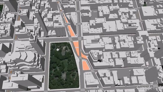
In this student project a semantic 3D city model of New York City (NYC) has been created based on datasets provided in the NYC Open Data Portal. Different 3D feature types were derived from existing public 2D and 2.5D datasets using spatial and semantic transformations together with (some) photogrammetric analyses. The resulting 3D city model is represented in a homogenized and integrated way using the international standard CityGML of the Open Geospatial Consortium (OGC). It comprises all NYC buildings, land parcels, roads, parks, the digital terrain model, and water bodies – all with 3D geometries. To the best of our knowledge it is the first publicly available big 3D city model of a large city in the USA which is based on official governmental data. We provide the resulting CityGML / KML / COLLADA / glTF datasets for download as Open Data as well as 3D web-based visualizations of the entire city model on this project web page. All data transformations and manipulations were performed using the ‘Feature Manipulation Engine’ (FME 2016.1) by Safe Software. The corresponding FME Workbenches, used to generate this city model, can be found on the project's GitHub page. Additional information on the project is available on this TUM-Wiki page.
The project was carried out in the context of the thee master theses of Barbara Burger, Berit Cantzler and Christof Beil within the master's program Geodesy and Geoinformation at TUM. The work of Burger and Cantzler provided the basis of the city model, comprising all NYC buildings, land parcels, roads, parks, the digital terrain model, and water bodies in LoD1. Building on this foundation, Beil further developed the city model, focusing on the representation of street space objects such as roadbeds, sidewalks or plazas as well as on new building models in LoD2.
Online Viewer Demo
Click here to launch the Online Viewer LoD2 Demo in your web browser. (Google Chrome recommended)
This Web Map Client Demo contains all street space objects as well as all building objects of New York City in LoD2. More than 1'000'000 building objects and more than 500'000 street space objects were generated entirely from Open Data. Multiple thematic layers, each enriched with a variety of semantic information, can be selected individually. All generated CityGML datasets are provided for download on this website.
Project Description
Virtual 3D city models are a spatial representation of the relevant entities within cities. 3D city models have traditionally been used for many application areas like urban planning, navigation, tourism, disaster management, training simulation and gaming. For most of these application areas the 3D visualization is of highest importance. In this project, a semantic 3D city model of New York City (NYC) has been created based on datasets provided in the NYC Open Data Portal. The resulting 3D city model is represented in a homogenized and integrated way using the international standard CityGML of the Open Geospatial Consortium. It comprises all NYC buildings, land parcels, street space objects, parks, the digital terrain model, and water bodies – all with 3D geometries. The NYC CityGML model has been exported to KML using 3DCityDB and can be visualized and exported using our new open source 3D Webclient which extends the Cesium Virtual Globe.
Attention! Please note that, with the exception of the LoD2 buildings, the data provided currently has a base height of 0m, i.e. the heights of roads and lots are not adapted according to the terrain so far. Due to the huge amount of data multiple thematically divided CityGML files were generated for each street space object class respectively. These include 11 thematic object classes with a total of 508,660 objects, each one assigned to the most fitting of the 3 possible subclasses 'Road', 'Square', or 'Track'. Additionally a smaller area around the famous ‘Flatiron Building’ was selected and enhanced with suitable textures to accomplish a more realistic visualization. Also, the data structure of this excerpt was adjusted by introducing ‘TrafficAreas’ and ‘AuxiliaryTrafficAreas’, thus further specifying individual street space objects and generating a LoD2 street space model. In order to express affiliations to Top-Level-Features each object was linked to superordinated ‘Road’, ‘Square’ or ‘Track’ objects.
Download Section
Download: LoD2 street space dataset for an example area in central Manhattan
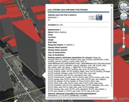
As each object has a base height of 0m, the terrain layer in Google Earth Pro needs to be turned off in order to achieve an accurate representation. Affiliations between Sub- and Top-Level-Features can be examined via mouseover effect.
Street space objects contained:
- Road: Roabeds, Sidewalks, Curbs, Intersections, Road Markings, Dividing Strips, Parking Lot Entrances
- Square: Plazas, Parking Lots, Sidewalks, Curbs
- Track: Interior Sidewalk
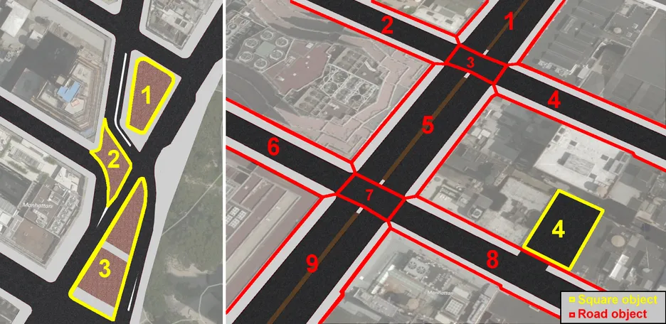
The image below visualizes the data structure of this extract CityGML file. Sub-Level-Features such as individual 'TrafficAreas' or 'AuxiliaryTrafficAreas' blong to certain Top-Level-Features like 'Road' or 'Square'. While object classes like 'Plaza' (yellow Nr. 1, 2 and 3) or 'Parking Lot' (yellow Nr. 4) belong to 'Squares', 'Roads' are composed of street space objects such as 'Roadbeds', 'Sidewalks' or 'Dividing Strips'. There are two different types of 'Road' objects represented, namely road segments (red Nr. 1, 2, 4, 5, 6, 8 and 9) and intersections (red Nr. 3 and 7) each identified by a respective 'citygml_function' attribute.
Download: LoD2 datasets for the entire city
Attention! The files generated for the entire city are in some cases very large when uncompressed. They can easily be imported into a CityGML compliant geodatabase system like our Open Source 3DCityDB. All street space objects were generated automatically for the entire city. Due to sometimes complex scenarios, this can lead to faulty results and thus should be handled with caution. Also bear in mind that the data structure of these 'Road', 'Square' and 'Track' files differs from the data structure in the excerpt file presented earlier, as each individual street space object is directly assigned to a Top-Level-Feature class.
Note! This project is a work in progress; the data sets provided will be improved and updated in the future.
Download: LoD1 datasets for the entire city (previous datasets, 2015)
The datasets generated in an earlier stage of the project (2015) containing LoD1 information on buildings, roads, and land parcels (lots) for the entire city can be downloaded from the following links.
- All Buildings (1,082,015 objects with all related addresses and up to 55 thematic attributes per object)
- All Roads (149,292 objects with up to 24 thematic attributes per object)
- All Lots (866,853 objects with up to 92 thematic attributes per object)
Click here to launch the Online LoD1 Viewer Demo in your web browser. (Chrome recommended)
Download: LoD0 network dataset for the entire city
Additionally a LoD0 network containing ‘Road’ and ‘Track’ objects represented as linear features with a variety of attributes and in 3D can be downloaded from the following link:
The tools, English papers on the project, the three Master's theses (in german) and their results can be downloaded from the list of publications below. Please note that these datasets have been derived from datasets of the NYC Open Data Portal. The copyright of the data remains with the original providers of the individual datasets. Links to the original datasets are included as External References (i.e. hyperlinks) with every CityGML object.
Potential Applications
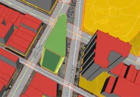
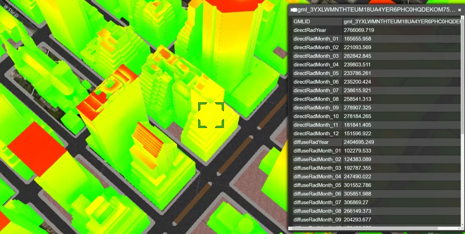
Digital city models and especially detailed areal representations of street space can be useful for a variety of different applications such as solar irradiation analysis, traffic simulations or land use management. The image below visualizes the results of a solar irradiation estimation for buildings in central Manhattan. All surfaces are textured corresponding to irraditaion values (kWh per year), ranging from bright green (low irradiation values) over yellow to red (high irradiation values). Different irradiation values (e.g. global, direct, diffuse, etc.) for each month of the year can be queried by clicking on a specific building.
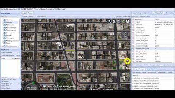
Using our Web Map Client Pro, extended analysis can be performed which are potentially useful for (urban) land use management, city asset management, or city planning. The city model presented contains a huge variety of semantic information such as street names, number of driving lanes, street area in m^2 or information on road surface conditions. These attributes can be queried in different combinations and thus be used for gaining additional information. The video below demonstrates possible applications. First, all traffic areas (roadbeds and intersections) belonging to 5th Avenue are selected. By summing up all corresponding 'area_sqm' values, the total surface area in m^2 of the road bed of 5th Avenue is calculated. Then, making use of information on street pavement conditions (rated with 1-3 = BAD, 4-7 = FAIR, 8-10 = GOOD), all roadbed objects (of the entire city) with a street pavement rating of 5 (lowest existing value) are selected. By calculating the total area in m^2 of the selected roadbed objects, assumptions on potential future repair costs can be made. (Fullscreen view recommended)
Currently, we are also working on using the NYC 3D street model to derive input datasets for the micro traffic simulation software VISSIM. Results of this project will be presented later this year.
Terms of Use and Disclaimer
The Chair of Geoinformatics at Technische University München provides these datasets for free usage. No warranties or guarantee on the correctness, completeness, or appropriateness for any specific use is given. In no case TUM / Chair of Geoinformatics can be held liable for damages, caused directly or indirectly, by using or working with these datasets or software tools. The data, software, and other materials are provided in unaltered state (“as is“), and no guarantee is given that it will run on or work with any specific system or operating system.
The data provided here is exclusively based on datasets provided in the New York City Open Data Portal (https://nycopendata.socrata.com). Since the 3D city model has been derived from NYC Open Data, all their terms of use and conditions apply here, too. These include the Terms of Use of NYC.gov (http://www1.nyc.gov/home/terms-of-use.page). According to the NYC Open Data terms of use, the originators of the individual datasets, i.e. the different departments of NYC administration, remain owner of the data.
Contact Person
M.Sc. Christof Beil
